![]()
By Bruce A. Wilson
The north-south trench cradling the Okanogan River has been used for centuries as a passageway connecting the Columbia River with the upper Fraser River.
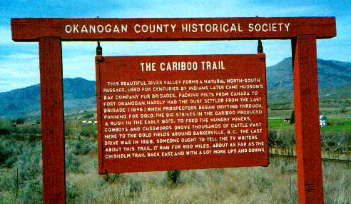
For about 13 years, from 1855 to 1868, pioneering cattleman and dollar-a-day cowboys moved cattle up the Cariboo Trail to mining camps in British Columbia. Fording rivers was always an irksome task, especially when the herd insisted on turning back.
The trail closely followed the Okanogan River. This river, from Lake Osoyoos to its confluence with the Columbia, drops only 125 feet in 77 miles.
So the north-south route through the Okanogan country is a gentle one, generously endowed with fresh water for travelers and grass and soft footing for livestock.
The passage enters Canada through a natural gateway, Lake Osoyoos. The normal surface elevation of Lake Osoyoos is 911.5 feet above sea level. This elevation makes Lake Osoyoos the lowest feature along the 49th parallel between summits of the Rocky Mountains and the Cascades.
Used by Indians for centuries, the route provided fur traders with an easy access to New Caledonia.
Only a few years after the final Hudson’s Bay Company fur brigade came down the corridor in 1847, miners were streaming northward toward gold strikes on the Fraser.
The route was sometimes referred to as "The Okanogan Trail." But its extension into the Cariboo mining district of British Columbia caused it to become labeled "The Cariboo Trail," and it is best known by that name.
The Cariboo Trail was more of a route than a trail. The miners and cattleman who used it sometimes came up one side of a river or lake, sometimes the other. They cut across open country freely.
The beginnings and end of the Cariboo Trail also are indefinite. At some point north of Wallula, or perhaps at Wenatchee if they were approaching from the Yakima country, travelers might feel they were following the Cariboo Trail. Certainly this would be the case from Fort Okanogan northward.
The trail extended to Williams Lake and Quesnel on the upper Fraser River and later to Barkerville. At Barkerville, queen city of the Cariboo mining district, nearly everyone turned out to welcome each of the herds reaching the end of the Cariboo Trail. As drovers moved wild-eyed cattle down the main drag, dogs created an uproar, cows bellowed, profane expressions rent the air, and mothers searched frantically for their children. But everyone looked forward to dining on fresh beef.
From Wallula, which was Walla Walla’s seaport on the Columbia River, the "main trail" crossed the Snake River near its mouth, skirted the east end of the Saddle Mountains, and traversed the Columbia basin east of Moses Lake.
Near the present site of Coulee City the trail branched, one route proceeding through the Grand Coulee, the other crossing the coulee to ascend to the Waterville plateau. Both alternatives then followed Foster Creek to strike the Columbia River where Bridgeport is today. Traffic crossed the Columbia there, or at the fort itself.
The Cariboo Trail continued up the east side of the Okanogan River, though twice it left the river. The first departure came where the Okanogan loops westward, north of Brewster. Here, the trail took a shortcut past Soap Lake on what is now the South Half of the Colville Indian reservation. Farther north, near Tonasket, a rock face forced the trail to detour through McLoughlin Canyon.
The trail crossed the Okanogan River at the lower end of Lake Osoyoos. It followed the western shoreline of Okanogan Lake, then struck northwesterly across Grand Prairie to reach the Thompson River near Kamloops.
From Cache Creek north the route more or less followed present Highway 97, some miles east of the upper Fraser River, which here flows through canyons and rough country.
Starting in 1860, miners reached Barkerville in the newly discovered Cariboo gold fields either by branching off from Williams Lake or continuing north to Quesnel, then east along the Quesnel River.
While most of the mining parties followed the "main trail" up the east side of the Okanogan River, nearly all of the cattle bound for northern camps were driven up the west side. They came from the Yakima valley through Kittitas valley, proceeding from Wenatchee up the west side of the Columbia.
The most dramatic happening along the Cariboo Trail occurred on or about July 28, 1858, when Indians, nervous over white intrusions, attempted to ambush a party of miners at McLoughlin Canyon, about four miles south of Tonasket. The ambush was triggered prematurely. This helped the miners’ advance party extricate itself from the canyon. A desultory battle continued for several hours.
The Cariboo Trail

![]()
