
![]()
In Quest For The Montana Mine & Mill

Remains of the historic Montana Stamp Mill located at an elevation of 4,500 feet
Information for this article was compiled, researched, and written by Cody Smith, Jerry Smith, and James O’Brien © 2005
The Montana Mine & Mill site is situated in a very remote, rugged, and almost inaccessible area approximately two miles in distance above Goat Creek. The mine and mill are located on Montana Creek at an elevation around 4,500 feet.
In 1944 there was one known claim filed on the Montana Mine by Henry and Homer Peters of Winthrop, Washington. This site was probably abandoned in 1946. Information compiled from “Inventory of Washington Minerals: Part 2” shows that a large quantity of ore mainly copper and gold, was processed from the mine. Other ore minerals included chalcopyrite, pyrite, arsenopyrite, and pyrrhotite. Hard-rock ore deposits from the mine consisted of mineralized quartz veins in siliceous-diorite country rock. In 1946 a sampling from the mine revealed an 85-foot adit and two caved-in adits, one, which may be 400 to 500 feet long.
Information On The Montana Mine From Washington Division Of Geology And Earth Resources Open File Report 90-18 November 1990
Lithology: Diorite
Age: Cretaceous
Commodities: Cu-Copper, Au-Gold
Ore Minerals: Chalcopyrite
Non-Ore Minerals: Pyrite, Quartz, Calcite, Arsenopyrite and Pyrrhotite
Deposit Type: Vein
Mineralization Age: Cretaceous
Production: Produced an unknown amount in 1915.
Tectonic Setting: The Fawn Peak stock was probably the intrusive rock core of an island arc.
Ore Controls: The deposit consists of veins in the actinolite zone of the Mazama porphyry molybdenum system.
Geologic Setting: The Montana deposit is in the Cretaceous Fawn Peak stock. It is an elongate, northwest-trending intrusion along the northeast side of the Methow River valley; it is situated along the axis of the Goat Peak syncline.
Hours of extensive research using GPS (Global Positioning System) inputs, old Topographic map readings, and collected mining knowledge compiling the history of this part of Washington State, led to an investigation of this historic relic from the past.
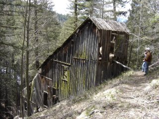
The Montana Mill was built on about a forty-five degree slope. Pictured here is adventure seekers Cody Smith and Stephen Jacobsen
On April 14, 2005 the investigative team of Jerry Smith, Cody Smith, Stephen Jacobson, and James O’Brien, adventure seekers from Boom Towns & Relic Hunters crew, started out on a quest. Its goal was to locate, photograph, document, and solve the mysteries surrounding what may be left of the historic Montana Mine & Mill.
Starting from their headquarters in Winthrop, Washington James O’Brien, an expert in the field of satellite GPS navigation, led the group on a heading north in the direction of Mazama and Fawn Peak. The group drove for several miles before utilizing a National Forest Service road, which followed Goat Creek for several miles. James O’Brien checked his preset coordinates on his GPS, which indicated that they needed to continue on this primitive road another 2.7 miles. As the explorers continued on their quest, they spotted an old, abandoned spur road leading them in the direction of Goat Creek.
At this point James took another guidance reading on his GPS, which indicated that they were on course to locate this relic from yesteryear. As the crew traversed this remote narrow spur road for about one mile, they came to a sudden stop. At this point the challenge facing them was a 100-foot vertical embankment, which dropped down into Goat Creek. Carefully, Cody, James, and Stephen descended. Their next challenge was crossing over the raging creek. They spotted a fallen tree across the creek, which would become the route to continue their unpredicted journey.
Once across Goat Creek safely another satellite reading was taken on the Garmin GPS. The reading indicated that they were, indeed, on track. The GPS revealed the Montana Mine & Mill’s location to be at 3,000 feet above their current position, near the summit of Fawn Peak.

The team crosses over Goat Creek to continue their unpredicted journey
Traversing brush and second-growth forest as they ascended they stumbled upon what appeared to be a narrow gage supply road. This old narrow gage spur road was without doubt used to transport machinery and equipment to the mill and mine, probably having used horses and mules. As they trudged towards the top, the narrow gage road would seem to disappear and re-appear. Over the years trees had grown over what was left of the road. Some areas of the road had slid down into the valley below.
After several miles of an exhausting two-hour climb the team crested a ridge. There, in plain sight, appeared the lonely and desolate remains of the Montana Mill and Bunkhouse. The Montana Stamp Mill appeared to be in fairly good shape. Approaching this isolated, remote spot at an elevation of 4,500 feet, the crew got closer to the mill’s location. The years had not been kind to her structure. The south wall of the Montana Mill was completely collapsed, brutalized by Mother Nature’s collective Winter-punishments.
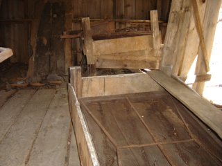
Inside the Montana bunkhouse with the wooden box spring beds
What still remained within the Montana Stamp Mill were the massive four-stamp crushers and rollers, once used to process its royal ores from the Montana Mine. Patent dates located on the huge stamp crushers dated from November 29, 1904. The mill had been built upon a forty-five degree-steep embankment located just above the Montana Creek. This certainly would have allowed snow loads to slide off of its structure over many winters. The mill’s structure appeared to be very fragile and appears destined for her last winters. It is, indeed, sad that a piece of history such as this will soon disappear forever.
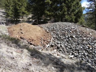
Looking in the direction of the Montana Mine and tailings
The team continued exploring. The old two-story bunkhouse still stood intact not far from the mine’s initial location. Peering inside the team discovered the remains of several wooden-box-spring beds once used by the miners. These beds would have been used to get a well-deserved-night’s rest. Scattered among the ruins were metal dinner plates and eating utensils, some still on the table. In one desolate corner of the lonesome bunkhouse stood the remains of an old cast iron cook-stove on whose front was forever emblazoned the label “Artic.” It was a stove that might have boasted of keeping Mark Twain cozy on his way to the Klondike. Should the stove have been ordered to speak, it would have told the story of the miners and prospectors whose luck had run out, making a hasty retreat to richer gold fields on the distant horizon.

Expedition team pictured from left, James O’Brien, Cody Smith, and Stephen Jacobsen
The team’s next quest was to locate the Montana Mine based on the input coordinates from James’ GPS. The Boom Towns & Relic Hunters crew split-up into teams and began exploring the hillsides nearest the mill for any signs of the once famous mine. Once forty-five minutes had gone by they gathered back at the mill to share information. The information proved to be useless. James consulted his GPS readings; Topographic maps, and concluded that the Montana Mine was most likely another 500 feet above them. The team continued following the GPS readings and climbing higher. They spotted what appeared-to-be ore tailings from a deserted mine. Burnt timbers lay scattered about in what resembled the entrance to the mine. Its portal had caved in and there was no visible entrance. A few hundred yards from this site the crew spotted a larger pile of tailings, which they went to investigate. Sure enough, as they approached the tailings, the mine’s portal appeared. Old ore-car axels and wheels were scattered about the ground. They were worn down by years of rust. Decades of harsh, wintry snow had partially caved in the main entrance. The explorers planned on someday returning with the proper safety equipment to investigate the mysteries within the historic Montana Mine. It was too dangerous to explore.
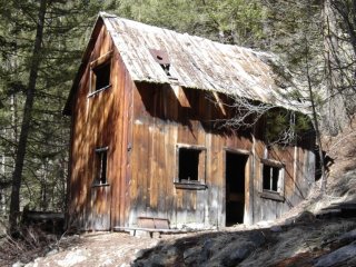
Historic Montana two-story bunkhouse still intact
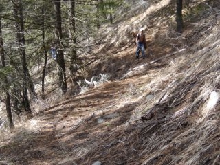
Narrow gage supply road was used to haul the massive equipment to the top of Fawn Peak
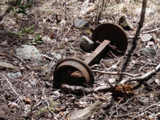
Old ore car axel and wheels used to transport the precious ore from within the Montana Mine

Main adit entrance to the Montana Mine. Pictured here is James O’Brien expert in the field of GPS navigation

Four-stamp crushers once used to process its royal ores from the Montana Mine
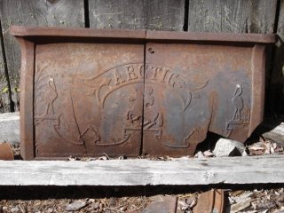
Remains of an old cast iron cook-stove on whose front was forever emblazoned the label “Artic”
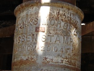
Patent dates located on the huge stamp crushers dated from November 29, 1904
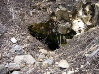
Another view of the main entrance to the historic Montana Mine
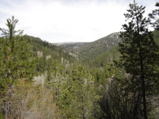
Looking in the direction of Fawn Peak and the Montana Mine & Mill site

This historic ore car remains at the Montana Mine as operations abruptly ended a century ago.
As this expedition came to a close;
Cody Smith, Stephen Jacobson, and James O’Brien departed this historic site, thoughts ran through their minds. They visualized what life might have been like during the Montana Mine and Mill heyday. Was there really any wealth from gold, silver, and copper mined and processed from the Montana Mine and Mill? If not, why would its custodians have hauled massive equipment to construct a 4-stamp crusher and rollers to the top of the mountains?
Or, was it all in vain and the miners and prospectors walked away leaving this piece of history to fend for herself for almost one-hundred years. It remained a mystery, that is, until this adventurous crew from Boom Towns & Relic Hunters located and revisited its remnants from another life and time in history?
Montana Mine & Stamp Mill GPS Coordinates-Using Map Datum WGS84
Montana Mine:
N48° 36.977' W120° 21.011'
UTM 10U 0695290E 5388190N
Montana Stamp Mill:
N48° 36.895' W120° 21.031'
UTM 10U 0695271E 5388038N
How Valley Hopes For Railroad
In the spring of 1910, the following letter extolling the virtues of the Methow Valley mining boom, was sent to Mr. M.J. Costello, assistant traffic manager of the Great Northern Railway Co. in Seattle.
Mining operations have been carried on in the hills around Twisp, Methow and above Winthrop for some years and considerable development accomplished in some of them. The principal ones worthy of mention are as follows:
The Alder Mine three and three quarter miles from Twisp have nearly 3,000 feet of development work. One carries gold and copper but is really a copper property. Fissure vein a Porphry dyke quartz vein 500 feet deep vertically, 120 feet wide at bottom and 80 feet wide in middle cross cut and 28 feet in upper cross cut. Have proved it to a horizontal length of 500 feet with cross cuts every 100 feet. The property is owned by R.S Lewis, Lieutenant Governor of North Dakota and associates. They claim they have spent $85,000 on the property and have $12 to $15,000,000 worth of ore in sight. They are asking three million dollars for the property.
Goat Creek, near Mazama, and twenty-four miles up south fork from Twisp has numerous prospects in locality. The American Flag has a 20 stamp mill and large vein of low-grade ore, average about $5.00. Crown Point has a good showing, considered one of the best in the district. A long but narrow vein 2 feet wide but solid. A smelting ore assays $56.00 gold and copper and 400 feet of tunnels.
Caywash Mining Company up Goat Creek three miles from Mazama has two tunnels 220 and 180 feet. Ore assays $8.00 to $40.00, and the vein being three and one-half feet wide. Yellow Jacket Group, on east side above Mazama intend selling to parties who will put in a stamp mill.
Montana Claim, on Goat Creek has had 12 assays averaging $65.00, highest $208.00, and lowest $18.00 from four-foot ledge.
The Lucky Jim across Goat Creek and in the same district is doing lots of work. T&B looks to be a good prospect.
There is an iron property at Camp Gilbert, 25 miles up Twisp River and in same district a group called the Spokane and St. Lawrence, a quartz property. The Crescent group has a nice ledge in the same locality with a tunnel and is making a good showing. The Squaw Creek Mining District below Methow has numerous prospects but not much work has been done.
The Hidden Treasure has a 10-stamp mill. The Friday Mine, four miles up from Pateros shipped some ore to Tacoma Smelter several years ago and got good returns but not much work being done. Lookout Group that is located near and above have a gasoline air compressor.
The State Creek District in Whatcom County has to come out this way. There is a big property in there called the Eureka and another called the Mammoth with large ore bodies.
The mining interests claim development work is retarded by lack of transportation. Ore in paying quantities is thought to exist up Lost River and south and east. No one has ever been in their and no prospecting or claims taken.
![]()
