
![]()
Lost “Ruby City” Cemetery Revisited
Ruby City, Washington was founded around 1888 in Okanogan County by prospectors and miners who had flocked there in large numbers, due in large part, to rich discoveries of silver ore. Within a brief period, Ruby, also known as the Queen City of the Okanogan County mining boom had become one of the liveliest and best-known mining camps in the Northwest.
The price of silver fell in the fall of 1892. Continuing to work the mines on Ruby Hill would have been unprofitable, so the prospectors and miners closed down the mining camps for good. As a result of people having moved away, vacant houses were left unprotected, and the once flourishing boomtown of Ruby bit the dust.
Since then, very little has been recorded about Ruby. In 2004, 116 years later, no one was left to offer creditable information about the lost and forgotten pioneer site of Ruby Cemetery.
Historians from nearby historical societies and museums had searched for years in hopes of locating the elusive Ruby Cemetery but without any luck. Fire swept through the area a few years after the downfall of Ruby consuming any wooden grave markers or wooden fence lines that may have marked the existence of the Ruby Cemetery site.
The only archival death records found for Ruby Cemetery were compiled from the Okanogan County death register from between the year’s 1891 and 1908 archived at the Okanogan County Auditors Office. Okanogan County records revealed three deceased persons that were laid to rest in the Ruby Cemetery, and the archival records from Ruby Cemetery recorded the deaths of these three individuals. The death register had been used for the first time around June 29, 1891 when:
L.L. Smith, age 25, a married white male and mechanic by trade, died of consumption. He originated from Texas. His father’s name had been Arch Smith and his mother’s maiden name had been J.T. Wheeler. He was followed in death by:
Wm. J. Hancock, age 32, a single white male carpenter, died of Typhoid fever November 18, 1892. He had come from Whidbey Island, Washington. His father’s name had been David Hancock and his mother’s maiden name had been Sarah A. Arthur. He was followed in death by:
Estella George, age 44, a white female widow whose trade was working as a washwoman. She had died of consumption February 9, 1892 and had originated from Indiana. Her father’s name had been Beumiefield and her mother’s name was unknown.
James O’Brien, a sales specialist in GPS navigation has over ten years of field experience and works as a GPS instructor at REI-Recreational Equipment Incorporated. Jim provides private instruction in using GPS equipment by his company “GPSNAV”. In the fall of 2003 he teamed up with Jerry Smith, local historian and author of Boom Towns & Relic Hunters of Northeastern Washington. The two have spent many long hours researching and documenting specifics on the lost cemetery of Ruby City, Washington.
The story of their quest to find the lost cemetery of Ruby City met with success on Saturday, May 29, 2004. Striking out from the Wild West town of Winthrop, Washington the two began exploring for the location of this long- lost and forgotten cemetery from the boomtown days of yesteryear. Using a Garmin GPS, U.S.G.S topographic maps, coordinates, research material, and hi-tech metal detectors the search commenced.
After driving for over an hour from their home base in Winthrop, Washington the team reached the Okanogan Valley in Northeastern Washington. The decision was made to begin heading northwest towards the once famous mining town of Conconully. Nearby the adventurers spotted Ruby Hill in the distance. Turning off onto the Salmon Creek road the team continued to explore in the direction of the famous ghost town site of Ruby, which was located 1.75 miles in distance from the turn off onto Salmon Creek road. Checking their GPS coordinates along the way, the research pair realized that they were getting closer to the lost cemetery as the miles narrowed. Approximately .7 miles from the old mining town site of Ruby City they spotted the remains of an abandoned dusty dirt road composed of rutted depressions zigzagging up sagebrush and pine tree covered hillside. On the opposite side of this road lay the Salmon Creek Road. Several boulders as large as houses dotted the location.
Both stopped and took a reading with the hand-held GPS device. Certainly this was the location they had been looking for, as indicated by the device. At long last they had located the lost Ruby Cemetery, six hundred yards up the hill. Beginning a steep climb following the old abandoned road, all the while observing the GPS readings in hopes of locating the legendary lost boot hill cemetery. After a fifteen-minute climb and a couple rest stops both were right on track with the GPS readings. The researchers entered a lonesome but beautiful valley of bunchgrass, sagebrush, meadows, and pine trees with a spectacular view of the surrounding mountains and hills.
Continuing their quest for the lost cemetery’s correct GPS center the GPS readings led them up a slightly sloping hillside overlooking a quaint valley. The GPS device confirmed that they were now standing smack in the middle of Ruby Cemetery. The historic and undisturbed spot showed no signs of having once been a cemetery. There were no wooden crosses, no old worn picket fences, no headstones, no rocks mounded up, nothing to indicate that this had once been Ruby Cemetery.
Remapping the area they staked out four corners and the center of the cemetery as the GPS readings had indicated. The entire area of the cemetery measured approximately fifty by seventy-five yards square, as depicted on the U.S.G.S. topographic map for T.35 N. and R.25 E., Section 29. (The GPS coordinates in both LAT/LON and UTM, based on map datum WGS84 would be listed later in the article). Laurie Smith and Lynda O’Brien, with their eight years of hands-on experience in the relic-hunting field, began their search. Starting with top-of-the-line, hi-tech, computerized metal detectors they swept the field for any artifacts that would prove Jerry’s and James’s theory, that this was, indeed, the true location of the historic Ruby Cemetery.
Continuing his search Jim scoured the landscape for any possible signs indicating grave site locations. In addition, Jerry took photos of the cemetery for future documentation. The documentation would be used at a later date.
Forty-five minutes after searching near the center of the cemetery Lynda got a good hit (sound) from her Fisher metal detector. As she pinpointed this sound she began to unearth evidence of this vanished cemetery. Sure enough, in the palm of her hand was a relic that would indicate that they had collectively located the lost Ruby Cemetery. The artifact of proof was a 2-˝ inch long square nail in perfect condition, which dated back to the time of Ruby City. A short while later, within an area not more than eight feet by ten feet square, Lynda had unearthed over thirty-five perfectly preserved square nails. The nails indicated that this spot was the last resting place back in 1892 of Estella, William or L.L. Smith.
According to the group’s theory a wooden picket fence enclosure, and possibly a woodenhead marker might have surrounded this grave(s) at one time. When a forest fire swept through the area around 1900 advancing flames, which destroyed everything in its path, devastated the area. This destruction included the woodenhead marker(s) and picket fence. Had the fire never occurred, the fence and head markers might have remained standing to this day. It would have pinpointed and acted as evidence of the lost Ruby City Cemetery. Certainly, many square nails are still entombed beneath the earth and sagebrush at this burial site, as well as other artifacts. The team has chosen to leave the cemetery undisturbed. It remains a monument to the past era of successful boom town days gone by.
Departing the site of Ruby City Cemetery the team felt deep sadness, but also joy. After more than one hundred years of being lost and forgotten the lost cemetery of Ruby City, Washington was no longer a mystery.
Today, visitors to historic Ruby Cemetery can take the Conconully Road, which travels north out of the town of Okanogan. One drives for a distance of about sixteen miles, and then turns left onto the Salmon Creek Road. Following this road southward for about 1.75 miles until you see a gated dirt road. The entrance is to the right and a large boulder field rests to the left. The entrance begins up the old wagon road leading to Ruby Cemetery. Should one want to visit the historic Ruby City ghost town site, where once saloons were full, gunfights reportedly were common, and inhabitants-mostly miners-experienced fires, floods, and the fear of Indians on the warpath, one need only drive another .7 miles down Salmon Creek road from the gated dirt road to find its location.
Mysterious “Ruby City” Cemetery GPS Coordinates-Using Map Datum WGS84
Elevation 2080ft |
119° 43' 24.5" W |
5376390mN |
|
Elevation 2080ft |
119° 43' 24.3" W |
5376405mN |
|
Elevation 1950ft. |
119° 43' 12.9" W |
5376028mN |
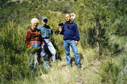
Research team at Ruby Cemetery site from left to right; Lynda O’Brien, James O’Brien and Jerry Smith.
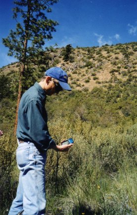
GPS specialist, James O’Brien confirming the lost Ruby Cemeteries correct GPS center.
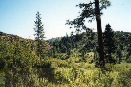
This is a bird’s eye view of the valley and surrounding foothills and mountains looking south from the historic Ruby Cemetery site.
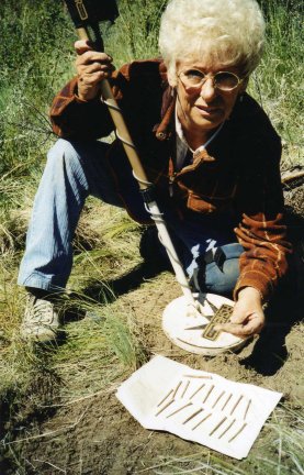
Pictured here is Lynda O’Brien with her hi-tech, computerized Fisher metal detector and her relics from the past. The artifacts of proof were several 2- ˝ inch long square nails in perfect condition, which dated back to the time of Ruby City.
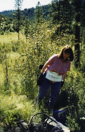
Pictured here are research team explorer and expert in the relic-hunting field, Laurie Smith looking for any possible signs indicating gravesite locations.
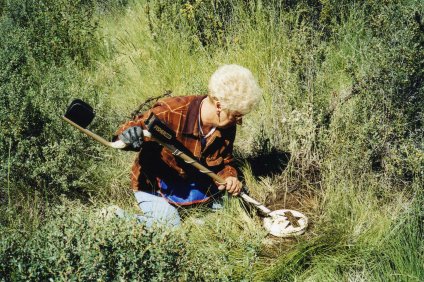
Expert in the field of artifact recovery Lynda O’Brien pinpoints her first hit (sound) with her detector and then unearthing evidence of this vanished cemetery.
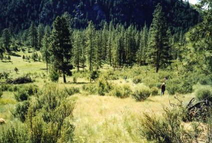
Research team re-mapping and staking out four corners and the center of the cemetery as the Garmin GPS readings had indicated.

Looking north towards the site of Ruby Cemetery where the researches had unearthed evidence that this spot was indeed the last resting place back in 1892 of Estella, William or L.L.Smith.
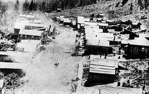
Ruby, Washington-Circa 1894. In 1894, Ruby had 29 businesses, including seven saloons and six general stores.
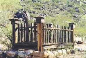
Perhaps in 1892 this photo depicts what the gravesite(s) would have looked like before the forest fire swept through the area around 1900.

According to the group’s theory a wooden picket fence enclosure, and possibly a woodenhead marker(s) might have surrounded the grave(s) at one time.
![]()
